State of Delaware
Delaware (![]() /ˈdɛləwɛr/) is a state on the Atlantic Coast in
/ˈdɛləwɛr/) is a state on the Atlantic Coast in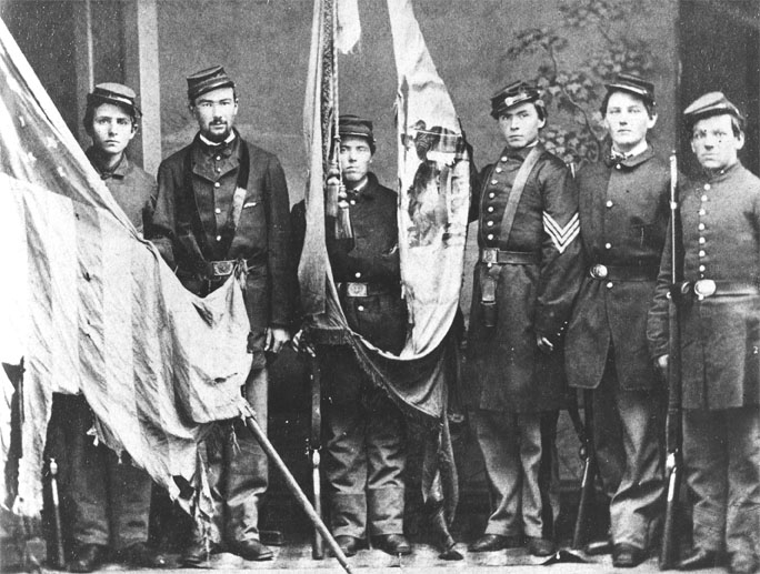 the Mid-Atlantic region of the United States. It is bordered to the south and west by Maryland, to the northeast by New Jersey, and to the north by Pennsylvania. The state takes its name from Thomas West, 3rd Baron De La Warr, an English nobleman and Virginia's first colonial governor, after whom what is now called Cape Henlopen was originally named.
Delaware is in the northeastern portion of the Delmarva Peninsula and is the second smallest, the sixth least populous, but the sixth most densely populated of the 50 United States. Delaware is divided into three counties, the lowest number of counties of any state. From north to south, the three counties are New Castle, Kent, and Sussex. While the southern two counties have historically been predominantly agricultural, New Castle County has been more industrialized.
Before its coastline was explored by Europeans in the 16th century, Delaware was inhabited by several groups of American Indians, including the Lenape in the north and Nanticoke in the south.
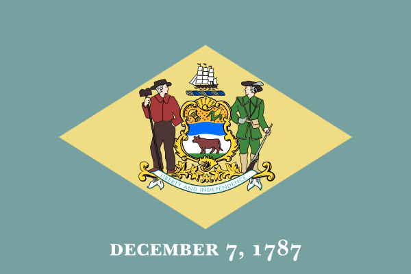
It was initially colonized by Dutch traders at Zwaanendael, near the present town of Lewes, in 1631. Delaware was one of the 13 colonies participating in the American Revolution and on December 7, 1787, became the first state to ratify the Constitution of the United States, thereby becoming known as The First State.
Etymology
The state was named after the Delaware River which in turn derived its name from Thomas West, 3rd Baron De La Warr (1577–1618), the governor of the Colony of Virginia at the time the river was first explored by Europeans. The Delaware Indians, a name used by Europeans for Lenape people indigenous to the Delaware Valley, also derive their name from the same source.
The surname de La Warr comes from Sussex and is of Anglo-Norman origin. It came probably from a Norman lieu-dit La Guerre. This toponymic could derive from the Latin word ager, from the Breton gwern or from the Late Latin warectum (fallow). The toponyms Gara, Gare, Gaire (the sound ä often mutated in æ) also appear in old texts cited by Lucien Musset, where the word ga(i)ra means gore. It could also be linked with a patronymic from the Old Norse verr.
Geography
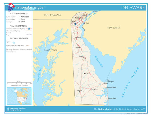 Delaware is 96 miles (154 km) long and ranges from 9 miles (14 km) to 35 miles (56 km) across, totaling 1,954 square miles (5,060 km2), making it the second-smallest state in the United States after Rhode Island. Delaware is bounded to the north by Pennsylvania; to the east by the Delaware River, Delaware Bay, New Jersey and the Atlantic Ocean; and to the west and south by Maryland.
Small portions of Delaware are also situated on the eastern side of the Delaware River sharing land boundaries with New Jersey. The state of Delaware, together with the Eastern Shore counties of Maryland and two counties of Virginia, form the Delmarva Peninsula, which stretches down the Mid-Atlantic Coast.
The definition of the northern boundary of the state is unusual. Most of the boundary between Delaware and Pennsylvania was originally defined by an arc extending 12 miles (19.3 km) from the cupola of the courthouse in the city of New Castle. This boundary is often referred to as the Twelve-Mile Circle. This is the only nominally circular state boundary in the United States.
This border extends all the way east to the low-tide mark on the New Jersey shore, then continues south along the shoreline until it again reaches the 12-mile (19 km) arc in the south; then the boundary continues in a more conventional way in the middle of the main channel (thalweg) of the Delaware River. To the west, a portion of the arc extends past the easternmost edge of Maryland. The remaining western border runs slightly east of due south from its intersection with the arc. The Wedge of land between the northwest part of the arc and the Maryland border was claimed by both Delaware and Pennsylvania until 1921, when Delaware's claim was confirmed.
Topography
Delaware is on a level plain, with the lowest mean elevation of any 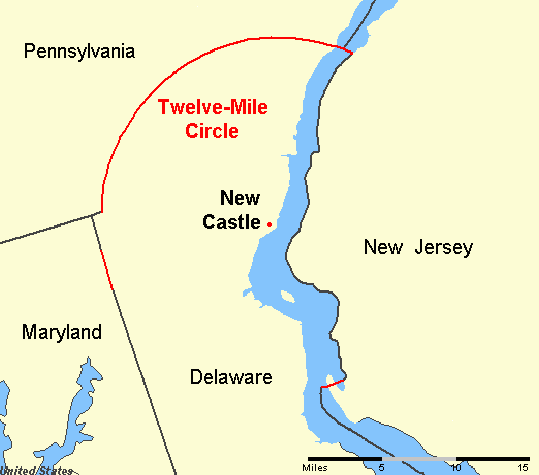 state in the nation. Its highest elevation, located at Ebright Azimuth, near Concord High School, does not rise fully 450 feet (140 m) above sea level.
The northernmost part of the state is part of the Piedmont Plateau with hills and rolling surfaces. The Atlantic Seaboard fall line approximately follows the Robert Kirkwood Highway between Newark and Wilmington; south of this road is the Atlantic Coastal Plain with flat, sandy, and, in some parts, swampy ground. A ridge about 75 to 80 feet (23 to 24 m) in elevation extends along the western boundary of the state and separates the watersheds that feed Delaware River and Bay to the east and the Chesapeake Bay to the west.
Climate
Since almost all of Delaware is a part of the Atlantic Coastal Plain, the effects of the ocean moderate its climate. The state is in a transitional zone between a humid subtropical climate and a continental climate. Despite its small size (roughly 100 miles (160 km) from its northernmost to southernmost points), there is significant variation in mean temperature and amount of snowfall between Sussex County and New Castle County. Moderated by the Atlantic Ocean and Delaware Bay, the southern portion of the state has a milder climate and a longer growing season than the northern portion of the state. Delaware's all time record high of 110 °F (43 °C) was recorded at Millsboro on July 21, 1930; the all time record low of −17 °F (−27 °C) was also recorded at Millsboro on January 17, 1893.
Environment
The transitional climate of Delaware supports a wide variety of vegetation. In the northern third of the state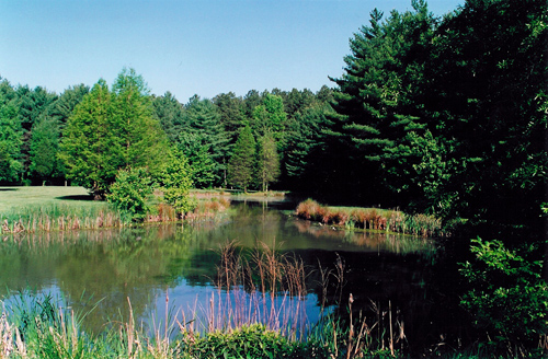 are found Northeastern coastal forests and mixed oak forests typical of the northeastern United States. In the southern two-thirds of the state are found Middle Atlantic coastal forests. Trap Pond State Park in Sussex County, for example, supports what may be one of the northernmost stands of bald cypress.
Environmental management
Delaware provides government subsidy support for the clean-up of property "lightly contaminated" by hazardous waste, the proceeds for which come from a tax on wholesale petroleum sales.
History
Native Americans
Before Delaware was settled by European colonists, the area was home to the Eastern Algonquian tribes known as the Unami Lenape or Delaware throughout the Delaware valley, and the Nanticoke along the rivers leading into the Chesapeake Bay.
The Unami Lenape in the Delaware Valley were closely related to Munsee Lenape tribes along the Hudson River. They had a settled hunting and agricultural society, and they rapidly became middlemen in an increasingly frantic fur trade with their ancient enemy, the Minqua or Susquehannock.
With the loss of their lands on the Delaware River and the destruction of the Minqua by the Iroquois of the Five Nations in the 1670s, the remnants of the Lenape who wished to remain identified as such left the region and moved over the Alleghany Mountains by the mid-18th century.
Generally, those who did not relocate out of the state of Delaware were baptized, became Christian and were grouped together with other persons of color in official records and in the minds of their non-Native American neighbors.
Colonial Delaware
The Dutch were the first Europeans to settle in present-day Delaware in the Middle regi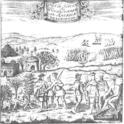 on by establishing a trading post at Zwaanendael, near the site of Lewes in 1631. Within a year all the settlers were killed in a dispute with area Native American Tribes.
In 1638 New Sweden, a Swedish trading post and colony, was established at Fort Christina (now in Wilmington) by Peter Minuit at the head of a group of Swedes, Finns and Dutch. The colony of New Sweden lasted for 17 years. In 1651, the Dutch, reinvigorated by the leadership of Peter Stuyvesant, established a fort at present-day New Castle, and in 1655 they conquered the New Sweden colony, annexing it into the Dutch New Netherland.
Only nine years later, in 1664, the Dutch were conquered by a fleet of English ships by Sir Robert Carr under the direction of James, the Duke of York. Fighting off a prior claim by Cecil Calvert, 2nd Baron Baltimore, Proprietor of Maryland, the Duke passed his somewhat dubious ownership on to William Penn in 1682. Penn strongly desired access to the sea for his Pennsylvania province and leased what then came to be known as the "Lower Counties on the Delaware" from the Duke.
Penn established representative government and briefly combined his two possessions under one General Assembly in 1682. However, by 1704 the Province of Pennsylvania had grown so large that their representatives wanted to make decisions without the assent of the Lower Counties and the two groups of representatives began meeting on their own, one at Philadelphia, and the other at New Castle.
Penn and his heirs remained proprietors of both and always appointed the same person Governor for their Province of Pennsylvania and their territory of the Lower Counties. The fact that Delaware and Pennsylvania shared the same governor was not unique. From 1703 to 1738, New York and New Jersey shared a governor. Massachusetts and New Hampshire also shared a governor for some time.
Dependent in early years on indentured labor, Delaware imported more slaves as the number of English immigrants decreased with better economic conditions in England. The colony became a slave society and cultivated tobacco as a cash crop, although English immigrants continued to arrive.
American Revolution
Like the other middle colonies, the Lower Counties on the Delaware initially showed little enthusiasm for a break with Britain. The citizenry had a good relationship with the Proprietary government, and generally were allowed more independence of action in their Colonial Assembly than in other colonies. Merchants at the port of Wilmington had trading ties with the British.
So it was that New Castle lawyer Thomas McKean denounced the Stamp Act in the strongest terms, and Kent County native John Dickinson became the "Penman of the Revolution."
Anticipating the Declaration of Independence, Patriot leaders Thomas McKean and Caesar Rodney convinced the Colonial Assembly to declare itself separated from British and Pennsylvania rule on June 15, 1776.
The person best representing Delaware's majority, George Read, could not bring himself to vote for a Declaration of Independence. Only the dramatic overnight ride of Caesar Rodney gave the delegation the votes needed to cast Delaware's vote for independence.
Initially led by John Haslet, Delaware provided one of the premier regiments in the Continental Army, known as the "Delaware Blues" and nicknamed the "Blue Hen's Chicks." In August 1777, General Sir William Howe led a British army through Delaware on his way to a victory at the Battle of Brandywine and capture of the city of Philadelphia.
The only real engagement on Delaware soil was the Battle of Cooch's Bridge, fought on September 3, 1777, at Cooch's Bridge in New Castle County.
Following the Battle of Brandywine, Wilmington was occupied by the British, and State President John McKinly was taken prisoner. The British remained in control of the Delaware River for much of the rest of the war, disrupting commerce and providing encouragement to an active Loyalist portion of the population, particularly in Sussex County. Because the British promised slaves of rebels freedom for fighting with them, escaped slaves flocked north to join their lines.
Following the American Revolution, statesmen from Delaware were among the leading proponents of a strong central United States with equal representation for each state.
Many colonial settlers came to Delaware from Maryland and Virginia, which had been experiencing a population boom. The economies of these colonies were chiefly based on tobacco culture and were increasingly dependent on slave labor for its intensive cultivation.
Most of the English colonists arrived as indentured servants, hiring themselves out as laborers for a fixed period to pay for their passage. In the early years the line between indentured servants and African slaves or laborers was fluid. Most of the free African-American families in Delaware before the Revolution had migrated from Maryland to find more affordable land. They were descendants chiefly of relationships or marriages between servant women and enslaved, servant or free African or African-American men.
As the flow of indentured laborers to the colony decreased with improving economic conditions in England, more slaves were imported for labor.
At the end of the colonial period, the number of enslaved people in Delaware began to decline. Shifts in the agriculture economy from tobacco to mixed farming created less need for slaves' labor. Local Methodists and Quakers encouraged slaveholders to free their slaves following the American Revolution, and many did so in a surge of individual manumissions for idealistic reasons. By 1810 three-quarters of all blacks in Delaware were free. When John Dickinson freed his slaves in 1777, he was Delaware's largest slave owner with 37 slaves. By 1860, the largest slaveholder owned only 16 slaves.
Although attempts to abolish slavery failed by narrow margins in the legislature, in practical terms, the state had mostly ended the practice. By the 1860 census on the verge of the Civil War, 91.7 percent of the black population were free; 1,798 were slaves, as compared to 19,829 "free colored persons".
The independent black denomination was chartered by freed slave Peter Spencer in 1813 as the "Union Church of Africans". This followed the 1793 establishment of the African Methodist Episcopal Church in Philadelphia, which had ties to the Methodist Episcopal Church until 1816.
Spencer built a church in Wilmington for the new denomination. This was renamed the African Union First Colored Methodist Protestant Church and Connection, more commonly known as the A.U.M.P. Church. Begun by Spencer in 1814, the annual gathering of the Big August Quarterly still draws people together in a religious and cultural festival, the oldest such cultural festival in the nation.
Delaware voted against secession on January 3, 1861 and so remained in the Union. While most Delaware citizens who fought in the war served in the regiments of the state, some served in companies on the Confederate side in Maryland and Virginia Regiments. Delaware is notable for being the only slave state from which no Confederate regiments or militia groups were assembled. Delaware essentially freed the few slaves that were still in bondage shortly after the Civil War, but rejected the 13th, 14th, and 15th Amendments to the Constitution; the 13th Amendment was rejected on February 8, 1865, the 14th Amendment was rejected on February 8, 1867, and the 15th Amendment was rejected on March 18, 1869. Delaware officially ratified the 13th, 14th, and 15th amendments on February 12, 1901.
Demographics
The United States Census Bureau estimates that the population of Delaware was 935,614 on July 1, 2014, a 4.2% increase since the 2010 United States Census.